Product Description
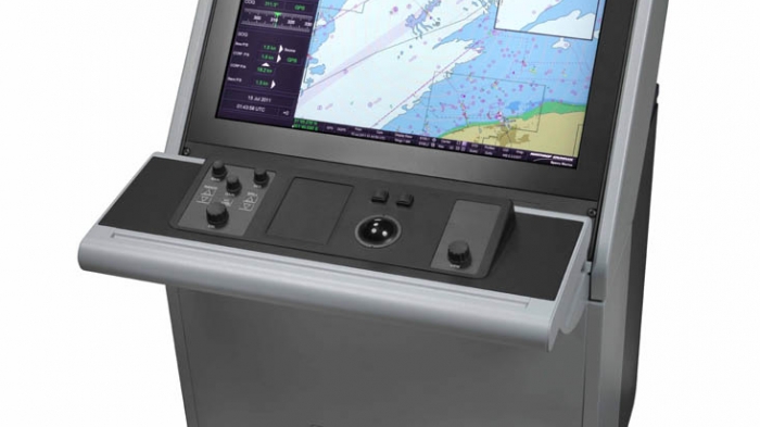
VisionMaster FT ECDIS
The Electronic Chart Display and Information System (ECDIS) allows quick access to tasks that are performed during a vessel’s operation. The clever design of graphic interface and colour coding allows the operator to assess the data at a glance and navigate stress-free.
Benefits of the VisionMaster FT ECDIS:
- Flexible and movable menu for quick access to chart related functions, sub-menus and clear overview
- Reduce risk by creating and testing multiple voyage plans without interruption of the navigation process
- Display charts from key chart suppliers such as C-Map, Admirality, SevenCs, Navtor Display charts from key chart suppliers such as C-Map, Admiralty, SevenCs, Navtor
- Flexibility in modes: Radar Overlay, ECDIS, Conning Info Display and Central Alarm Management
- From standalone ECDIS to a multi node networked system (optional)
Fully compliant
The VisionMaster FT ECDIS is fully compliant with the International Maritime Organisations’ (IMO) regulations for paperless navigation and electronic chart display. It provides a separate, redundant backup station in case the primary ECDIS navigation station is damaged or disrupted. Our highly reliable, flexible navigation solution provides improvements in performance to enhance the ship’s safety at sea. The ECDIS also includes ADMIRALTY Information Overlay (AIO), making additional chart information available to ships’ navigators,
From Radar to ECDIS
The standard platform of the VisionMaster FT Series has demonstrated to be the best system available in the marine industry. Using the same interface throughout the series makes it easy to upgrade from Radar to ECDIS, for efficient operation and minimised training.
Safe Navigation
VisionMaster FT ECDIS
To optimise full-screen viewing of the chart display, the VisionMaster FT ECDIS features menu bars and menus that disappear when not in use. During the voyage, an alternative route can be added, which can be displayed simultaneously. Waypoints can be moved, inserted, added or deleted instantly and easily or exchanged via the alternative route with route in progress, at your own convenience.
Split-screen function
The split-screen function (one of five display modes) permits two independent charts to be shown simultaneously, in addition to the option to displaying the same navigational picture at different chart scales. The intuitive handling of the display is supported by the use of Windows.
The ECDIS is flexible and easily connects to a wide range of navigation equipment to acquire more information. The ECDIS will display exactly the info you need in a clear, uncluttered format, reducing the risk of accidents.
Conning Information Display
To reduce the cost of systems which permanently display Central Alarm Manager (CAM), a Conning Information Display (CID) control is available which shows the CAM output. The CID control can be on a dedicated CID screen and displayed either as CID watch mode or as a side tab on widescreen ECDIS, eliminating the need to have a dedicated node for the CAM display.
Streamlined chart information
The ECDIS gives quick access to tasks to be performed during a vessels operation. The intelligently arranged graphic user interface gives quick access to functions available in each mode, with full-time display of sensor data. The navigation process is streamlined to reduce confusion and risk, enhancing situational awareness. The clever design of graphic interface and colour coding allows the operator to assess the data at a glance and navigate stress-free.
Charts
The ECDIS automatically associates radar and Automatic Identification System (AIS) targets to minimize mistaken identity and simplify watch standing. The system’s Universal Chart Manager is designed to work with a broad range of authorized vector and raster charts, including S57, C-Map, ARCS and PRIMAR.
Optional Features:
Fuel Savings
The Fuel Navigator is a voyage decision support system that has been developed to provide saving on ships fuel cost by optimising route, speed and engine mode. The system uses a simple, intuitive interface that is integrated to the VisionMaster FT ECDIS system.
Key Features of Fuel Savings:
- Automatic integration of weather and ocean current data
- Advanced customised ship modeling for optimisation
- Active voyage optimisation by adjusting waypoints, speed and engine mode settings
- Optimal route can be executed manually, via autopilot and/or speed pilot
- Weather and ocean current forecasts can be overlaid on the ECDIS charts
- Animated weather and ocean current as the ship sails its route
ECDIS with Radar Overlay
The VisionMaster FT offers practical radar usage with ECDIS, more than just overlaying a rough radar image. The radar image has a high resolution when interfaced with Northrop Grumman Sperry Marine radars. The radar image does not hide the priority objects of vector charts, but overlays them on the radar image. At the same time, brilliance and clutter controls of the radar images continue to be operable.
IMO Compliance
VisionMaster FT ECDIS
The IMO Safety of Navigation circular, covering “maintenance of ECDIS software” (SN.1/Circular 266) states that: “an ECDIS that is not updated for the latest version of IHO Standards may not meet the chart carriage requirements as set out in SOLAS regulation V/19.2.1.4″. We recommend checking your ECDIS software for compliancy here. Or find more information on the IMO and IHO standards.
Admirality Overlay
VisionMaster FT ECDIS
Admirality Overlay now available with new software release
Northrop Grumman’s VisionMaster FT (VMFT) software now includes ADMIRALTY Information Overlay (AIO) as an integral element of its Electronic Chart Display and Information System (ECDIS) based navigation system making additional chart information available to ships’ navigators.
Is My VisionMaster FT ECDIS IMO Compliant?
Select your VisionMaster FT software version and check the compliancy of your ECDIS against the latest IMO and IHO standards to verify whether your ECDIS software needs to be upgraded.
For more information about Northrop Grumman Sperry Mrine’s VisionMaster FT ECDIS, please contact us.
OUR COMPANY GROUPS


PRODUCTS GALLERY


